Come Closer
- Share
- Tweet
- Pin
- Share
“Thanks to the Interstate Highway System, it is now possible to travel across the country from coast to coast without seeing anything.”
– Charles Kuralt
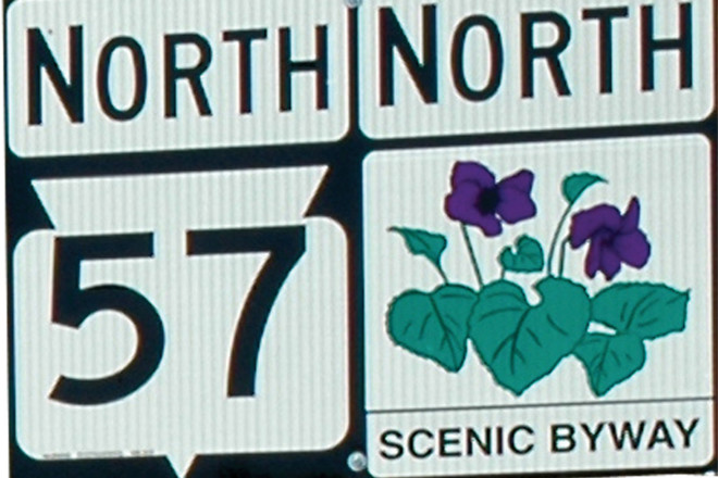
Astute travelers along Door County’s main highways will notice a recent change. Sometime during the
Photo by Heather Frykman.
bleak months of winter, clusters of purple wood violets appeared next to the ubiquitous black and white Highways 42 and 57 indicator signs that dot Door County’s most traveled roadways. In small print below Wisconsin’s state flower are the words “Scenic Byway.”
On April 6, 2010, a 66-mile stretch of Highways 42 and 57 was officially declared a Wisconsin Scenic Byway. It joins two other Scenic Byways within the state – the Great River Road, a 2,000-mile stretch of highway that follows the Mississippi River and the 100-mile Lower Wisconsin River Road from Lodi to Prairie du Chien in south-central and southwestern Wisconsin.
What is a Scenic Byway?
According to the Wisconsin Department of Transportation (WisDOT), Scenic Byways are “highway corridors that offer travelers outstanding scenic views combined with recreational and/or cultural attributes.” To qualify, a roadway must be a numbered state highway and the route being proposed for designation must be at least 30 miles long. Furthermore, the application process must be initiated by a local community and have local buy-in and support.
Photo by Heather Frykman.
Unlike Rustic Roads, which typically highlight native terrain and wildlife in rural settings, a Scenic Byway may be a busy, well-traveled thoroughfare. Although it may be noisy and frenetic, travelers on it must be able to hear the whisper of the Scenic Byway theme…Come closer.
A Scenic Byway is not just a road but a cultural experience. It encourages a traveler to pull over, explore further, and take a closer look. Like the sirens of Greek mythology, it should sing a song sweet and seductive enough to lure and detain a stranger and make him forget, momentarily, his native land. Unlike the interstate system, a Scenic Byway allows visitors to be immersed in and “see” the culture and landscape they travel.
According to Mary Denis of the Door County Visitor Bureau, the Scenic Byways program responds to a resurgent desire people are feeling for a sense of place. For many people, Scenic Byways are a destination in and of themselves. “Visitors, particularly of the baby boom generation, are drawn to places rich in history, not just cookie cutter, anywhere USA experiences. Door County has always offered that and the Scenic Byways designation allows us to improve on it, protect it and share it both regionally and, hopefully, nationally.”

Photo by Heather Frykman.
Wisconsin’s newest designee, officially dubbed the Door County Coastal Byway (DCCB), begins just north of Sturgeon Bay where Highways 42 and 57 split. The Scenic Byway travels north up the Green Bay side of the peninsula, hugging the Niagara Escarpment, to Northport. Its southern route travels along Lake Michigan from Sister Bay back to the junction of 42 and 57 north of Sturgeon Bay. Along this loop, the only municipality choosing not to be incorporated into the byway is the Town of Egg Harbor. Washington Island, having no numbered highway, is not eligible.
Forming a Vision
The true starting point of any Scenic Byway, however, isn’t a coordinate on a map. The true starting point of a Scenic Byway is a person or persons who form a vision and carry it through to completion. In Door County, that person happens to be a female ASE-certified auto mechanic/krautmeister and one of the nicest people you could hope to meet. (You know what they say…behind every Scenic Byway there’s a congenial car-fixin’ cabbage grower. Well, if it’s not universally true, it’s true for us.) Meet Annie Miller,

Photo by Lucas Frykman.
the driving (no pun intended) force behind Door County’s new Scenic Byway.
Miller and her husband, Jim Gordon, live north of Baileys Harbor not far off of Highway 57. Their house is built on the Miller family farm, and her father still lives next door. When asked how she became a mechanic Miller succinctly explains, “I bought a lemon.” She was 27 and the “pretty, shiny Pontiac” she bought broke the first day she owned it. That led to Milwaukee Area Technical School where she earned her degree in Automotive Repair.
She and her husband now own A.M. Enterprises, a conglomerate that includes an auto care service center, a historic log cabin vacation rental property, a farm that produces more than 20 varieties of fruits and vegetables and the locally-famous Door County Kraut Company. One of their many business cards reads “krautmeisters,” and the title is earned. Miller and Gordon process and package between 1,000 and 1,500 pounds of cabbage a year. In her spare time, Miller serves on the Liberty Grove Town Board. In explanation of her varied pursuits, she says, “You do what it takes to stay here. I’m not bored, and I’m not gathering any moss.”
Photo by Lucas Frykman.
Miller doesn’t fit any mold and perhaps that’s what attracted her to the Scenic Byways idea. Door County doesn’t fit a mold, either, and the Scenic Byways program is designed to celebrate that.
We’re seated at her kitchen table and Miller explains how the idea of a Scenic Byway came about. It all began with the proposed Gills Rock Harbor of Refuge in 2008. Exploring funding options, the Harbor of Refuge committee invited Dennis Leong from the WisDOT to do a presentation on Wisconsin’s Scenic Byways and the federal grants eligible to byway communities. “I sat and listened to how the byways program can bring federal money to local communities and promote economic growth,” says Miller, “and I thought ‘this could be us.’ Every time we put gas in our cars, we pay federal taxes. We may as well get some of it back. I don’t think we’re any less deserving than other places.”
Although the Gills Rock Harbor of Refuge didn’t prevail, the idea of the Scenic Byway did. Miller explains, “With the Town of Liberty Grove as our sponsoring municipality, we formed an ad hoc committee in February of 2009. It consisted of Frank Forkert, Jeanne Majeski, Kim Shumway and myself. Our first big hurdle was to get the cooperation of all the municipalities along the proposed route.

Photo by Lucas Frykman.
We knew there was no point in proceeding until that happened. We held lots of meetings and talked to every governing board. By that summer, eight municipalities had signed on and the County of Door had given its blessing.”
Beauty is in the Eye of the Beholder
With the first hurdle cleared, the committee was ready to tackle Phase I of the application process, the Scenic Assessment. To ensure a measure of objectivity, the WisDOT has created a scoring method that’s used to determine the relative quality of every mile along a proposed route based on its scenic views and significant historic sites. Once that is determined, each mile is assessed for “distractions.” Every off-premise sign (a sign not attached to the business or attraction it promotes) is considered a distraction as are communication towers and dilapidated buildings. Each distraction reduces that mile’s base score by a point. Each mile is then assessed for its “complementary resources.”
A complementary resource is defined as a historical/archeological, recreational or cultural amenity. Each documented amenity along or near the route adds a quarter-point to the base score. American Folklore Theatre, Peninsula Players Theatre, Birch Creek Music Center, Cana Island Lighthouse, The Clearing, state and county parks, The Ridges Sanctuary, art galleries and orchards are all examples of DCCB amenities. Well-established events are also considered amenities – even Polar Bear Plunges!

Photo by Lucas Frykman.
“The Scenic Assessment was our road show,” laughs Miller. “We piled into Frank Forkert’s motor home early one Sunday morning and didn’t return home until late that afternoon. We literally stopped every one-tenth of a mile to photograph and record amenities and distractions. It makes you look at the things around you in a whole new way.”
Following the committee’s assessment, the WisDOT sends a team of four from the state to do its own evaluation. Miller recalls one instance when the state’s assessment differed from the committee’s. It involved the weathered and rustic farmhouse, barns and outbuildings on the northwest corner of West Meadow and Highway 57 north of Baileys Harbor. The state team deemed the property a distraction while the county committee considered it an amenity.
“They don’t think much of peeling or unpainted buildings,” Miller explains. “When we pointed out that this is a historic farmstead that’s in the process of being restored, we were able to convince them to take it out of the distractions column and add it to the amenities column!”
The WisDOT requires that a majority (70 percent) of the proposed corridor exhibit scenic qualities and no more than 30 percent of the corridor display major distractions. On December 8 of 2009, Miller and Gordon drove to Madison to be on hand for the Wisconsin Scenic Byway Advisory Board meeting “to answer any questions and to nervously wait for the decision.” Unanimous approval was given to the Door County Coastal Byway and Phase II of the application process began.
Photo by Heather Frykman.
Promotion and Protection: The Benefits of Scenic Byway Status
Phase II of the Scenic Byways application involves writing a Corridor Management Plan (CMP). The CMP outlines a community’s 10-year plan for the protection and preservation of the route as well as its promotion and enhancement.
According to Miller, the plan identifies potential projects and stresses the need to “take what Door County has and make it more viable, to protect the treasures and resources found in our community and to promote them in a way that attracts tourists and allows local families increased economic stability. We want people to be able to make a life here, to be able to afford to stay.”
As Miller suggests, Scenic Byways are not just for visitors. Scenic Byway status confers a number of benefits to the corridor communities as well. Chief among them is the eligibility to compete for Federal Scenic Byway discretionary grant funds. These funds may be used for interpretive centers, to bury power lines, to establish bike paths, construct scenic overlooks, etc. and can provide up to 80 percent of total project costs. The remaining 20 percent must come from a local sponsor either in the form of cash or in-kind contributions.
Photo by Lucas Frykman.
According to the Wisconsin Scenic Byway’s Citizen Handbook, designation also “supports tourism and economic development…strengthens civic pride, and makes communities more attractive places to live and work.”
Frank Fiorenza, Village President of Potosi, Wisconsin couldn’t agree more. Potosi is situated along the Great River Road and has a population of 711. As a corridor community, it has applied for several Federal Scenic Byway grants. In 2004, Potosi received a $450,000 grant to help build the Great River Road Interpretive Center and revitalize a historic brewery. In 2005, they were awarded nearly $400,000 for the National Brewery Museum and a visitor center. Increased tourism due to these projects has led to the construction of a convention center, the opening of an art gallery, the Potosi Brewery Company Transportation Museum, a working brewpub and rental cabins. Most recently, Potosi received a $100,000 grant to build the Potosi Point Wildlife Observation Platform, an aviary observation deck overlooking the Mississippi River flyway.
“We just announced the beginning of construction and already we’re getting phone calls from people who want to come and visit,” says Fiorenza. “Potosi was a dying river town. It’s now on its way back to being a vibrant community and the Scenic Byway program has certainly been a contributing factor.”

Photo by Lucas Frykman.
Door County based its CMP on the Door County 2030 Comprehensive “Smart Growth” Plan and had it reviewed by many individuals and agencies. By WisDOT dictates, it’s imperative that all participating municipalities understand the benefits and the restrictions of the program. For instance, in order to be eligible for grant funds, communities must agree to follow the Federal Highway Administration prohibition on the erection of any new billboards and other off-premise signs along the designated corridor. Existing signs may remain and be maintained.
The Door County Coastal Byway committee submitted its CMP in March of 2010. As it says on the DCCB website, “It was a very happy day April 6, 2010 when we received a letter from Secretary of WI DOT, Frank J. Busalacchi, that he had approved the Phase II document submission and granted us Scenic Byway Status.” The Door County Scenic Byway was official. From start to finish, the process took just over a year and beat all previous records.
What’s Around the Next Bend?
Photo by Dan Eggert.
When asked about what’s next for the DCCB committee, Miller has a ready answer: apply for the grants needed to erect Niagara Escarpment interpretive signage in participating communities, fund a Niagara Escarpment Interpretive Center and receive National Scenic Byway status within 10 years – an ambitious goal, but with their track record, a credible one.
Several area non-profit organizations are in the process of submitting Federal Scenic Byway discretionary grant applications. The Door County Land Trust already submitted one and is awaiting notification.
When summarizing the effort thus far, Miller is astounded by the cooperation and effort the Door County community has put forth. Although she estimates that she has personally contributed over 1,000 hours of time, she shrugs it off and laughs. “It just keeps dragging you in a little further. You start to see all the ways this designation could help our communities and that’s very exciting.”
Photo by Lucas Frykman.
The Door County Coastal Byway committee has received help from the Door County Visitor Bureau which donated website and logo design services. The Town of Sevastopol provides administrative help. Len Villano has donated photography services. The list goes on and on and on. No fewer than 28 non-profit organizations, governmental agencies and business associations are listed as partners on the DCCB website.
No matter where Door County’s Scenic Byway leads in the future, it has already accomplished much. “We have a wonderful team,” states Miller. “There’s a strong sense of camaraderie in the county around this project. We knew we lived in a great place; the byway has reinforced that.”
Information![]()
The Door County Coastal Byway committee meets on the second Wednesday of every month at various locations throughout Door County. The public is invited to attend. Information about the DCCB, including how to make a much-appreciated contribution of support, is available at www.doorcountycoastalbyway.com. The Coastal Byway Corridor Management Plan may be viewed on the county’s planning department website: www.map.co.door.wi.us/planning.