Day One of Sturgeon Bay Waterfront Trial
- Share
- Tweet
- Pin
- Share
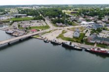
Attorneys on either side of the west side waterfront redevelopment case between the City of Sturgeon Bay and the Friends of the Sturgeon Bay Public Waterfront spent the morning debating the accuracy and validity of maps ranging back to the 1800s. In these maps and in surrounding soil samples lies the answer to the proposed hotel’s encroachment on Wisconsin waters under the Public Trust Doctrine.
“There is consistency in the shorelines in the depiction of the bay shown around the [hotel property],” said Donald Chaput, a veteran surveyor with Chaput Land Surveys and the first expert witness from the Friends. “There are multiple maps produced from multiple sources, produced during multiple time periods, so collectively they provide some sense of consistency and assurances that the shore looked like that during that time period.”
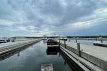
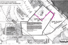
Where the shoreline is, and more importantly the Ordinary High Water Mark (OHWM), is the center of the entire suit. Wisconsin’s Public Trust Doctrine, as part of the state constitution, explicitly prohibits the use of land below the OHWM for private purposes even if the water has been filled in, such as the case on Sturgeon Bay’s west side.
The OHWM is the spot on land where the water typically ends. It doesn’t change with fluctuations in water level, so anything below that mark is public land and is protected under the state constitution.
The Friends contend that the proposed hotel sits on filled lakebed below the OHWM and is public land that cannot be sold to a private developer. The city believes the hotel is above the OHWM.
The first morning of the trial focused on historic maps to settle this dispute.
The Friends attorney, Mary Beth Peranteau, put a series of historical maps before Chaput, who had overlaid them on top of each other to show where the shoreline was historically leading up to the implementation of a municipal bulkhead line in 1955.
Taking maps from the Army Corps of Engineers, Wisconsin Historical Society, Sanborn Fire Insurance and surveys, Chaput stated that the correlation of the maps mean accuracy. That accuracy showed the proposed hotel property to encroach on land that used to be water.
But on cross examination, the city’s attorney, R. Valjon Anderson, questioned both the accuracy of the maps and credibility of Chaput himself.
“Nowhere on your CV is it listed that you have training in locating an ordinary high water mark,” said Anderson at the outset.
From there, Anderson turned to the maps submitted by Peranteau. On some of the maps, he noted that they were intended for educational and nonprofit use only and that many of the Sanborn maps were simply pieces of old maps stitched together into one.
His most persistent argument was that one of the overlays of a plat of the west wised waterfront shows rectangular lots that are sitting halfway in the canal.
“The historical maps certainly have a degree of error in them,” Chaput conceded. “They were produced at different period of time, different individuals, different levels of quality.”
Judge Raymond Huber echoed this concern.
“Historically was it part of your profession when platting property to draw plats with rectangular lots even if a portion of a lot may not be conveyable because it’s underwater?” asked Huber following the examination from both attorneys.
“I do not recall seeing another plat of that nature,” replied Chaput.
Anderson and Attorney Remzy Bitar continued on this trend of attempting to invalidate the evidence presented by the Friends attorney.
When Nancy Aten took the stand to describe maps and old newspaper articles that were to be entered as evidence, the city’s attorneys called out her close ties to the Friends group and Midwest Environmental Advocates, both monetarily and through her husband, Dan Collins. The defendant made no comment on anything in Aten’s direct examination besides objecting to the hearsay inherent in historic newspapers.
The plaintiff’s final witness of the day was Lori Huntoon, a geologist who reviewed the soil borings surrounding the proposed hotel property. The soil samples were part of an environmental assessment the city did before developing the land.
Huntoon testified on both the status of the filled lakebed and the validity of some of the maps used during the trial.
“The Sanborn maps provide an extensive amount of information which we find in our industry to be extremely precise,” said Huntoon, commenting on the maps that the defendant sought to discredit during Chaput’s testimony.
“The conclusions all were such that the area is fill overlying lakebed. Based on historical sources as well as the soil borings that were installed, that it was fill overlying lakebed deposits,” said Huntoon.
Despite a majority of Huntoon’s testimony reviewing different soil types found in the borings, the defendants struck out at her praise of Sanborn maps and her lack of experience with ordinary high water marks.
“You’ve never ever worked on the analysis of an ordinary high water mark, correct?” Bitar asked in a number of different ways.
Bitar then attempted to dismantle Huntoon’s claim that the soil borings truly indicated filled lakebed, but ran into lengthy explanations of what makes up fill and how soil borings are taken.
Huntoon maintained that the area must be filled lakebed following her analysis of the soil samples taken from the site.
If the land is determined to be filled lakebed, it is likely that the Public Trust Doctrine will support the Friends’ claim that the land should be public as it would likely put the hotel property in the water if this was before 1955.
“I was very pleased with the way the evidence came in. It is fully consistent with what we’ve been telling folks in Sturgeon Bay for years now,” said Peranteau after the first day of the trial. “I think that most people were aware through publicity about the lines on the map evidence but maybe less people were familiar with the geological evidence.”
Bitar and Anderson declined to comment following the first day of the trial.
“Here’s the thing, we’ve got the law and the facts on our side so what would you do if you’re opposing that? You’re going to nip around the edges, you’re going to try and create confusion and that’s the attempt on the other side,” said Dan Collins of the Friends.
The City of Sturgeon Bay will call three witnesses on the second and final day of the trial, beginning at the Door County Courthouse at 8:30 am on Friday, Feb. 10.