Department of Transportation Targets Stone Piles Along Highway 57
- Share
- Tweet
- Pin
- Share
At a special morning meeting on Feb. 9, the Liberty Grove Town Board asked town attorney Jack Bruce to try to negotiate with the Wisconsin Department of Transportation (DOT) regarding the removal of stones from the roadway in conjunction with a Hwy. 57 resurfacing project taking place later this year.
The board said the result of that discussion will determine whether the town takes legal action to prevent removal of stones.
The issue of the stone fences and rock piles along Hwy. 57 was first brought up at a March 2014 meeting in Baileys Harbor, when the project was scheduled to take place in 2016 (the work is now scheduled to begin after Labor Day). DOT project manager Jeremy Ashauer explained that “encroachments” within 18 feet of the roadway would have to be moved. He said those items would be identified during the design process and property owners would be alerted if action was required.
“If the DOT has known about this since 2014, why haven’t they notified the landowners,” Baileys Harbor resident Annie Miller asked at the town board meeting.
Town Supervisor Nancy Goss said landowners still have not received letters, despite the DOT’s May 1, 2017, deadline to take action on the “encroachments.”
In an email, Ashauer identified what the DOT says can stay and what must be moved.
“With an attempt to balance the competing priorities of safety and aesthetics, we came up with the following that we are moving forward with:
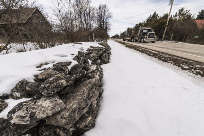
- All rock walls that are formed in a stacked manner that provide a wall look will be preserved and allowed to remain in the right of way under a revocable permit. The revocable permit allows the wall to remain in place until such a time as it needs to be maintained or rebuilt, at which time it shall be relocated off the right of way. The revocable permit also allows WisDOT to revoke the permit in the future, especially if this was to become a safety issue.
- All rock piles will be removed within the clear zone of the highway. This is established as being 18 feet from the edge of the travel lane. Rock piles are those that are loose rock that does not provide a wall look and are predominantly hidden by other vegetation through most of the year. Letters will be sent to property owners informing them of our intent to remove rock piles to the clear zone as part of the project and, if desired, they may retain the rocks by removing them prior to May 1, 2017 and relocating them to outside the highway right of way. The rock pile portions that reside outside of the clear zone will be allowed to remain in place for now.”
Ashauer added that research conducted during the DOT’s environmental assessment found that the stone piles and fences along the corridor “were not found to be of archeological or historical significance,” a statement that astounds Dr. Joanne Kluessendorf, director of the Weis Earth Science Museum at the University of Wisconsin-Fox Valley in Menasha.
“Unfortunately, the ‘rock piles’ are the fences with the historical rural/geological significance,” she said. “The stacked stone fences are those that have been installed as landscaping in recent years, and have no historical/geological significance. Apparently, geological significance was ignored, and I would contend that there is historical significance as well,” she said. “I don’t know of anyone with geological expertise relevant to this aspect of Door County geology who was contacted for their opinion.”
Kluessendorf explained why these field rocks are special.
“They are the remains of 430 million-year-old coral fossils that once lived in a shallow sea that covered much of Wisconsin and the Midwest during the Silurian Period of earth’s history,” she said. “In particular, these coral skeletons had been chemically transformed from their original calcium carbonate composition into a silica-rich composition, which gave them a superior resistance to weathering and allowed them to be eroded out of the surrounding limestone rock, so they would occur as isolated ‘boulders.’ The silica also imparts a beautiful sparkling character to the corals. Because of the structure of the Niagara Escarpment and Cuesta, which are made of the Silurian-age rocks, these corals are found only on the eastern part of the Door Peninsula because of the tilt of the rock layers, and are only found in the fences in that area and not across the entire peninsula. These fences, therefore, have historical significance for Door County that goes back not just to the early European settlers but hundreds of millions of years back to when Wisconsin was located in a tropical setting south of the equator, in an environment much like that of the Bahamas today. Those fences are a primary source of the corals that inhabited that ancient ocean.”
DOT Timeline for Hwy. 57 Project
Location/limits: Baileys Harbor to Sister Bay, South Junction of County Q to Hwy. 42.
Length of project: 8 miles
Construction schedule: September to November 2017, starting after Labor Day weekend.
Description of work: This project is primarily a resurfacing project, and will include the removal of the existing box culvert at Mudd Creek and replacement with a single-span bridge. Other work includes culvert replacements, minor drainage improvements, beam guard replacement, permanent signing and pavement marking.
Traffic impacts: Hwy. 57 will be closed to through traffic from Labor Day weekend to Fall Fest weekend, both weekends exclusive. Work after Fall Fest weekend will be completed under open roadway conditions with flagging operations.
Detour: Detour will follow County Q to Townline Road to Hwy. 42.