Land Trust Map Encourages Exploring the Door
- Share
- Tweet
- Pin
- Share

The Door County Land Trust distributed hiking maps to area school children, including Mr. Deggendorf’s third grade class at Sunrise Elementary School in Sturgeon Bay.
Area elementary school children were recently encouraged to explore Door County when the Door County Land Trust distributed over 1,600 copies of its newly published, “Hiking Trails of the Door County Land Trust” map.
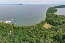
The foldout map features 13 of the Land Trust’s nature preserves from Little Lake on Washington Island to the Sturgeon Bay Ship Canal and Legacy at Clay Banks preserves along Lake Michigan.
“We’ve got absolutely beautiful nature preserves to share, each with trails and a parking area and each one different from the next. We’ve been working hard to get the preserves ready for the public over the past few years, and we’re thrilled to have people visit and discover them,” said Tim Stone, president of the Door County Land Trust board of directors.
Distribution of the “Hiking Trails of the Door County Land Trust” was met with enthusiasm from the staff and kids at Sunrise School in Sturgeon Bay.
Ann Smejkal, principal of Sturgeon Bay Elementary schools commented, “We are grateful to the Land Trust for providing maps to the hiking trails for our students. Door County has so much to offer our students and their families, especially for promoting exercise and a healthy lifestyle – this map is a great resource!”
A complimentary copy of the “Hiking Trails of the Door County Land Trust” map may be requested on the Land Trust’s website, http://www.doorcountylandtrust.org.