Open Spaces and Wild Places
- Share
- Tweet
- Pin
- Share
The Door County Land Trust is celebrating 25 years of preserving Door County’s finest open spaces and wild places. Over the course of the summer and fall, this column will feature one of the special places the Land Trust is working to protect.
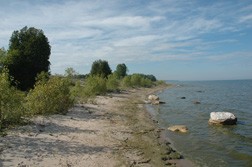
The Legacy Nature Preserve at Clay Banks offers what is arguably one of the most breathtaking views along Lake Michigan in all of Door County. From the top of a windswept bluff, a bucolic, open field stretches to the edge of a high clay bank and cascades down to a sand beach to meet the sparkling blue waters of Lake Michigan. From the preserve, the Door County peninsula stretches northeastward out into the open lake. The preserve features over one-half mile of pristine shoreline, a cedar-filled wetland, open fields, a meandering stream, and, of course, the steep bluff that bisects the preserve. This biologically diverse mix of habitat provides an ideal home for many plants and animals including shore birds, bald eagles and a number of rarely encountered wildflowers.
Clay Banks Township was named for the famous red clay banks that line the shore in this southern-most portion of Door County. These red clay banks are uplifted beach remnants of the last Ice Age. In more recent times, they’ve served as conspicuous navigational landmarks for the many ships that have travelled between the ports of Milwaukee and Sturgeon Bay.
The Door County Land Trust is challenging people to visit all of the places featured in this column. People are encouraged to email [email protected] when they accomplish this feat and to have their name entered into a drawing to win a copy of the Land Trust’s Guide to the Places We Protect due to be published this fall. For more information on the Land Trust and to download preserve trail maps, visit http://www.doorcountylandtrust.org.
Just the Facts: Legacy Preserve at Clay Banks
Acres protected: 91
Miles of trails: 1.3 miles of easy to moderate trails
Partnering organizations: The Legacy Nature Preserve at Clay Banks was established due to the generosity of Nancy and Susan Kreuter who made a bargain sale to the Door County Land Trust. Support was also received from the U.S. Fish and Wildlife Service, the Knowles-Nelson State Stewardship Fund and Land Trust donors.
Directions: From Hwy 42/57 in Sturgeon Bay, travel south on County U (Clay Banks Road) approximately six miles. Take a left and travel east on Salona. Take the next right onto South Lake Michigan Drive. The preserve parking area is 1.8 miles ahead on the east side of the road.
Did you know? At one time, the village of Clay Banks, now completely disappeared, was a bustling lumber settlement. It housed a sawmill, numerous businesses and schools, and several post offices. It had the longest pier in Door County and according to the Wisconsin Underwater Archaeology Association, this was needed because the waters offshore had many “shallow reefs, rock ledges, and bottom boulders.” The marine topography here has resulted in many documented shipwrecks. In fact, several wrecks remain submerged just off the coast of the nature preserve.