Dry Winter and Spring Equal an Elevated Fire-Risk Season
- Share
- Tweet
- Pin
- Share
Statewide wildfires this year almost double the 10-year-average
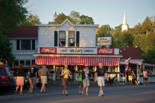
It’s probably one of the worst calls that Katie Krouse, executive director of The Ridges Sanctuary in Baileys Harbor, could have received – an area resident reported smoke from the direction of The Ridges pickerel ponds along the shores of Moonlight Bay.
“This is a very isolated spot with very poor access, and it was incredibly alarming that there might be a fire back in that area,” she said. “There was a concern that a recent storm had a lightning strike that started a smoldering fire that then began to spread once the winds picked up on Monday. Another concern was that it was human-started.”
The Baileys Harbor Fire Department was dispatched around 4 pm on Monday, April 15.
“We went down Ridges Road and then by Stone Mill Lane to try and narrow it down, and couldn’t find anything,” said Chief Brian Zak. “That’s when I requested a drone.”
The Town of Gibraltar Fire Department responded with its drone, which detected the smoke and pinned the GPS coordinates over the top of a house near the Ridges Appel’s Bluff property. Not only did that help firefighters locate the source quickly, it eliminated the need to disturb natural areas.
“They didn’t have to use the brush hog to make paths to isolated areas to find the fire,” Krouse said.
When firefighters arrived on the scene at the source of the smoke, they found a homeowner having a “campfire,” as Zak said the homeowner called it. But it didn’t have the required metal or stone campfire ring, and amounted to a brush fire surrounded by logs, Zak said. There also wasn’t a burn permit, which would have, among other things, notified the fire department of the potential source before multiple fire departments were dispatched.

“Northeast Wisconsin is in a high fire danger [last week],” Zak said. “Permits are required on a daily basis for burning.”
No harm resulted from the incident, but that’s not the situation across Wisconsin at the height of the state’s fire season – right after the snow melts and prior to vegetation greening up. Usually, the season moves from south to north. This winter’s lack of snowfall has meant no snow cover across the whole state since February, said Catherine Koele, Department of Natural Resources (DNR) Wildfire Prevention specialist.
“So it’s been a busy season – we’ve about doubled the number of fires this year on the 10-year average,” Koele said.
The DNR’s Wildfire Dashboard showed, as of Tuesday, April 23, there have been 560 wildfires this year that have burned 1,095 acres. The 10-year-average is 266 wildfires. The size of the fires has also grown, according to the dashboard, with 47 of this year’s fires larger than five acres, versus 22 larger than five acres over the 10-year-average.
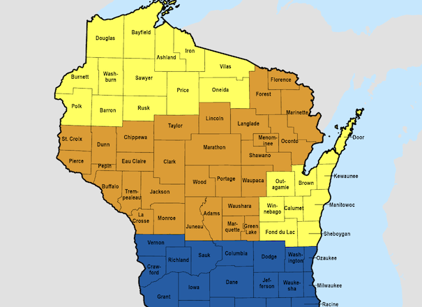
The DNR regulates burning rules and manages wildfires in 43 counties in the state – considered DNR Protection Areas – and Door and Kewaunee counties, and the Fox Valley region – considered Cooperative Areas – are not among those.

“It dates back to the 40s, and historical memos of understanding with towns, and now it’s in statute and code,” Koele said, about the counties the DNR does and does not manage – though billable services are available to all 72 of Wisconsin’s counties.
“Certainly we have the equipment and training and resources anywhere in the state,” Koele said.
Without DNR management, the rules and where to purchase a burn permit differ by Door County municipality.
“It does provide some challenges, and for some of our messaging,” Koele said.
That’s because the DNR does manage fire danger statewide and updates the fire danger risk for all Wisconsin counties based on state-wide weather tools and stations that measure temperature, wind speed and humidity. Foresters on the ground in Door County can also transmit conditions by taking pine-needle samples, for example, and measuring the moisture to know how fires would be burning with the fuel on the ground.
Though the forecast showed rain by the time this issue of the Peninsula Pulse came out (April 26), the DNR asked the public not to burn for two weekends prior due to elevated fire danger after it responded to 122 fires the week of April 15 alone – the most active wildfire week this season.
The DNR said the wildfire season was expected to continue for several more weeks and the fire danger rating for Door County as of April 23 was “high” – meaning wildfires ignite easily, spread rapidly and can be challenging to control.
Even with an approved campfire ring and a burn permit, Zak said it’s important for people to consider these fire danger ratings, and the risk-reward of an outdoor campfire.
“Is it worth having a campfire considering how dry and windy it is,” Zak said.
Not from where Krouse sits, given the Ridges 1,600-plus acres of unspoiled, natural fuels.
“I certainly don’t ever want to receive that phone call again,” Krouse said. “It is a horribly overwhelming situation, and I’m grateful to the Baileys Harbor fire department and all of the departments that came to Baileys Harbor to support this issue.”
Check Fire Hazards
Daily Wisconsin Department of Natural Resources (DNR) burn restrictions are determined by fire danger ratings, also set by the DNR. Fire danger ratings describe the potential for a fire to start and spread and the intensity at which a fire will burn. The ratings are based on weather, fuels and changes in the general landscape. To learn the fire danger risk anywhere in the state, go to apps.dnr.wi.gov/wisburn/#/. The DNR’s Wildfire Dashboard is at dnrmaps.wi.gov/wildfiredashboard/.