Become A Weather Spotter: Training Offered April 6
- Share
- Tweet
- Pin
- Share
“In ‘language’ not difficult to read, the vast face of the sky tells us what the weather is going to be.”
– Louis D. Rubin Sr., The Weather Wizard’s Cloud Book
The late Mr. Rubin, known as the Weather Wizard, published his book on reading the clouds in 1970, with the acknowledged purpose of creating a non-technical book to get more people to enjoy watching clouds and forecasting weather. With his book in hand, people only had to figure out the wind direction, look at the clouds and match what they were seeing to one of the full-color cloud photographs in the book to determine what the weather was up to.
The National Weather Service would also like you to look to the skies, but not just for your own enjoyment.
“We can use as many eyes watching the weather as possible when severe storms are possible,” said Jeff Last, warning coordination meteorologist with the National Weather Service in Green Bay, which is conducting a series of severe weather spotter training sessions throughout northeastern Wisconsin in the next month, including a session at Crossroads in Sturgeon Bay at 6 pm on April 6.
“We’ve been offering the training in the weather service for many decades, since at least the 1970s,” Last said. “In the last 20 years or so, we’ve restructured the training to make it more inclusive to get the public involved.”
Last said having trained eyes on the sky is essential for severe weather warnings.
“It helps us update our warnings and forecasts with more accurate information,” he said. “Doppler radar gives us a really good idea of what’s probably happening, but a human being can tell us exactly what’s happening. Our storm spotters are really an important part to a successful severe weather warning situation.”
Asked if he could recall a circumstance where spotters assisted the weather service, Last doesn’t ponder long before mentioning the tornado that hit Door County the evening of Aug. 23, 1998.
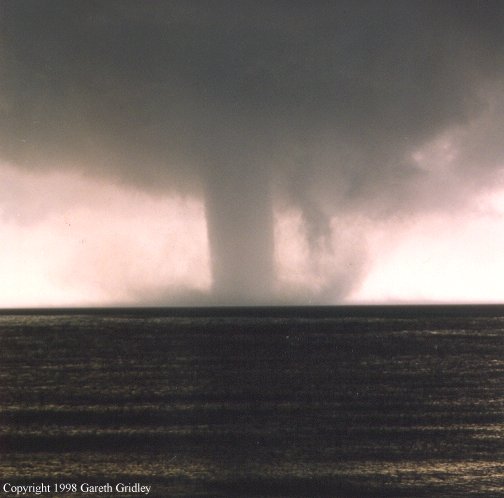
This photograph of the Aug. 23, 1998, storm was taken by Gary Gridley from Egg Harbor. The photo of the approaching storm on Green Bay was taken about five minutes before the tornado came ashore at Murphy Park.
“We had a large tornado move on shore from the bay to near Carlsville and continue to the east,” he said. “That tornado was spotted over the water by several storm spotters. It was a pretty large tornado. From those reports with our Doppler radar, we were able to issue a tornado warning almost 20 minutes before it hit the coast, which gave citizens quite a bit of lead time to get in their basements or take protective action.”
The multiple-vortex tornado was on the ground for nearly 14 minutes, wreaking havoc along a 5.1-mile path of destruction that ranged from ¼- to ½-mile wide. Damage was estimated at nearly $7 million. Only two people were injured, which may be attributed to the early warning from the storm spotters.
Last said the storm spotter training takes about 90 minutes.
“During that time we talk about some of the cloud precursors to severe weather, how to identify which thunderstorms are stronger than others just by looking at the clouds, and we talk about resources, how people can keep abreast of the weather situation using our webpage and online apps and things like that.”
While Last said some of the storm spotters in northeastern Wisconsin have been around as long as he has served at the Green Bay office – almost 22 years – there is always a need for more spotters.
“We have quite a few who have been helping us out for many, many years. They know it’s important because they know they are helping not only the weather service but they are helping out their community,” he said. “It’s good to have new spotters because some people may be on vacation or just not around, so we try to recruit as many people as possible every spring. I’m hoping we’ll have a great crowd on April 6.”
Photo by Len Villano.
Matt Lang, who serves on both the Ephraim and Sister Bay/Liberty Grove fire departments, is a big believer in the weather spotter training.
“It’s a really good course to go through and it’s good training if you get in a storm situation and you want to know what you’re looking at,” he said.
Lang manages the Door County Area Skywarn Facebook page.
“We’ve been around since 2011,” he said. “It kind of started out as a group interested in severe weather reporting and reporting. All members are required to take the course to become certified weather spotters.”
Lang said most of the members of the group are members of emergency services throughout the county.
“I got involved just because it’s an aspect of emergency services,” he said. “There was really a need in the county and throughout the state to have trained Skywarn spotters who are able to provide that truth to what the radar is showing the meteorologist in the warning center at the National Weather Service because they are always looking for reports to verify the radar they are getting in.”
Lang said there is always a need for more weather spotters in the county.
“The county is a challenge because it is so geographically diverse,” he said. “Ideally, we would like to have people throughout the county spotting and reporting.”
In addition to the Door County weather spotter training on April 6, a session will be held at 6 pm on April 27 at the Kewaunee County Fairgrounds in Luxemburg. You can also sign up for online spotter training at weather.gov/grb/spotterschedule.
Staying Safe is Key for Spotters
The environment in and around severe storms is a dangerous place. Even though tornadoes are an obvious danger, other life-threatening thunderstorm hazards, such as lightning and flash floods, can be just as deadly. Spotter reports are vital to your community and the NWS, but your safety should be your number one priority. Before venturing out, you need to be aware of the hazards of thunderstorms and the recommended practices to minimize risk. As a spotter, it is your responsibility to stay safe while spotting. Please follow the guidelines below for your personal safety and for the safety of those around you.
- Personal safety is the primary objective of every spotter.
- Adhere to the concept of ACES (Awareness, Communication, Escape Routes, and Safe Zones) at all times. ACES is a concept commonly used by emergency management personnel. If you remember ACES, you can remain safe in any situation, including spotting.
- Obey federal, state, and local laws and directives from public safety officials.
- Never put yourself in harm’s way. This includes attempting to walk or drive over obstructions such as flooded roadways and downed power lines, and positioning yourself under objects that have a potential to fall or be blown over due to severe weather.
From the National Weather Service Spotter’s Field Guide, which you can find online at srh.weather.gov/jetstream/downloads/spottersguide.pdf.
Prepare Yourself for Tornadoes
To give families a chance to test their emergency plans, a statewide tornado drill will be held during the evening of April 14. The drill is part of the annual spring severe weather campaign to encourage people in Wisconsin to get ready for possible tornadoes and severe weather.
April 11-15 is Wisconsin’s Tornado & Severe Weather Awareness Week. Wisconsin Emergency Management, the National Weather Service (NWS) and the Wisconsin Broadcasters Association (WBA) have once again teamed up to sponsor the statewide tornado drill.
A mock tornado warning will be issued at 6:55 pm on Thursday, April 14, to give families and businesses a chance to test their emergency severe weather plans. A mock tornado watch will be issued at 1 pm and a mock tornado warning will be issued at 1:45 pm. Many radio and TV stations across the state will issue the test tornado warnings. In addition, mock alerts will be issued on NOAA Weather Radios and many communities will sound their tornado sirens.
According to the NWS, Wisconsin averages 23 tornadoes annually. Last year, there were 17 tornado touchdowns in the state.
If actual severe storms are expected in the state on April 14, the tornado drills will be postponed until April 15, with the same times. If severe storms are possible Friday the drills will be canceled.