Voting With New Maps
- Share
- Tweet
- Pin
- Share

When voters head to the polls in November they will vote within legislative districts that have been redrawn based upon a bipartisan agreement reached earlier this year by the Legislature and the Governor.
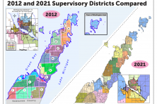
The changes do not impact Door County voters, who vote in District 1, as can be seen in comparative maps prepared by Marquette University Law School research fellow John Johnson. Assembly District 1 is the same. Senate District 1 changed – the district is now more contiguous, picking up areas east of DePere and south down to New Holstein, but losing the Two Rivers area – but not in a way that impacts Door County.
The new legislative districts were drawn by Gov. Tony Evers, passed by Republican lawmakers and signed into law by Evers, Feb. 19. This all came after the Wisconsin Supreme Court tossed the state’s legislative maps in December 2023, and invited the legislature and governor to seek an agreement.
“Republicans explained their sudden support for Evers’ map as simply picking the worst of several bad options,” Marquette University’s Johnson wrote. “In Senator Van Wanggaard’s words, ‘Republicans were not stuck between a rock and a hard place. It was a matter of choosing to be stabbed, shot, poisoned or led to the guillotine. We chose to be stabbed, so we can live to fight another day.”
Republicans had drawn the maps in 2011 and redrew them in 2021, helping the GOP maintain majorities in the Assembly and Senate. Those maps were gerrymanders and didn’t deserve consideration, according to the two consultants hired by the Wisconsin Supreme Court. Those consultants – Jonathan Cervas with Carnegie Mellon Institute for Strategy and Technology and Bernard Grofman with the University of California-Irvine School of Social Sciences – also said in their report that with new maps, the party that won the most votes would win the most seats.
Republicans in the Wisconsin Assembly currently have a 64-35, near-supermajority. In the Senate, Republicans have the largest majority (21-11) held by one party since 1979, according to the Wisconsin Legislative Reference Bureau.
The new maps are now expected to shift the balance of political power in Wisconsin, discrediting the long-held Republican belief that Wisconsin’s “political geography” favored Republicans because Democratic voters were clustered in large cities.
“To put it simply, in Wisconsin, geography is not destiny,” Cervas and Grofman wrote.
Applauding the new maps locally was Indivisible Door County, with members Karen Wilson and Mike and Judy Brodd traveling to Green Bay on Feb. 20 where Evers appeared after signing the bill in Madison a day earlier.
“We were honored to be invited to participate in the event,” said Mike Brodd on behalf of Indivisible Door County, who recognized the many years of persistence by citizens across the state to get the maps redrawn to create more parity. “Democracy in Wisconsin has been reborn with the Governor’s pen.”